
Nanda Devi Raj Jat 2026 Schedule: Complete 22-Day Itinerary, Route Map & Guide
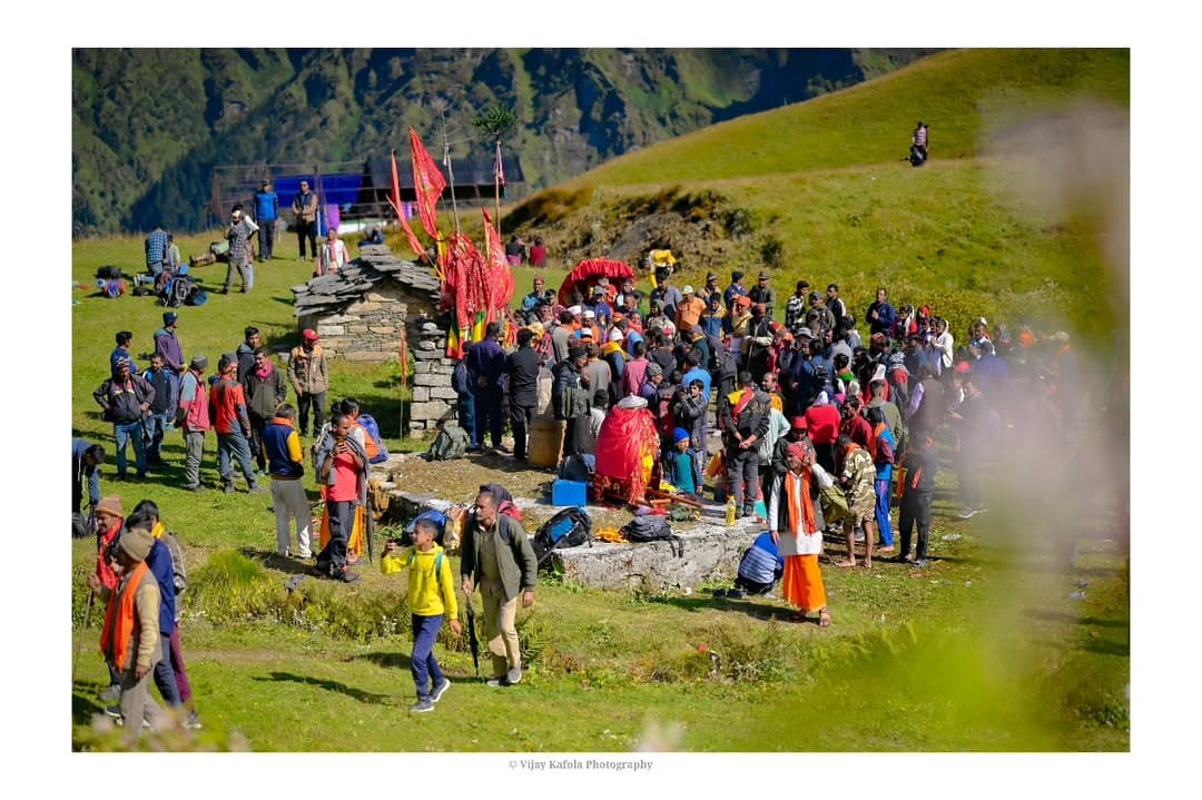
Table Of Content
- Introduction: The Sacred 12-Year Pilgrimage of the Himalayas
- Nanda Devi Raj Jat 2026: Quick Overview
- Complete Day-by-Day 22-Halt Itinerary & Schedule
- Phase 1: The Valley & Village Procession (Days 1 to 10)
- Phase 2: The High Alpine Wilderness & Glacial Passes (Days 11 to 16)
- Day 11: Mundoli to Wan Village (Latu Devta Temple)
- Day 12: Wan to Gairoli Patal / Bedni Bugyal
- Day 13: Bedni Bugyal to Pataar Nachauni
- Day 14: Pataar Nachauni to Kalu Vinayak & Bhagwabasa
- Day 15 (CRITICAL DAY): Bhagwabasa to Roopkund, Junargali & Homkund
- Day 16: Homkund to Shila Samudra & Chandaniya Ghat
- Phase 3: The Return Journey (Days 17 to 22)
- Key Traditions & Ritual Symbols
- Important Rules & Essential Guidelines for Pilgrims
- Frequently Asked Questions (FAQs)
- Conclusion: Preparing for the 2026 Gathering of Faith

Introduction: The Sacred 12-Year Pilgrimage of the Himalayas
Every 12 years, the quiet mountain valleys of Chamoli in Uttarakhand transform into the stage for one of humanity’s most awe-inspiring spiritual journeys: the Nanda Devi Raj Jat. Spanning 280 kilometers on foot, traversing dense oak forests, lush alpine bugyals (meadows), and high-altitude glacial passes up to 16,500 feet, this 22-day pilgrimage is often called the Kumbh of the Himalayas.
At its heart, Nanda Devi Raj Jat is a poignant emotional journey. It represents the sacred farewell (Bidaai) of Goddess Nanda (an incarnation of Goddess Parvati) as she leaves her maternal home (Mait) in the foothill villages of Garhwal and Kumaon to join her consort, Lord Shiva, at his celestial abode in Mount Kailash and Homkund.
Whether you are a devout pilgrim, a mountain trekker, or a cultural researcher preparing for the upcoming Nanda Devi Raj Jat 2026, this guide provides the complete day-by-day schedule, detailed 22-halt itinerary, elevation profiles, ritual significance, and practical preparation advice.
Nanda Devi Raj Jat 2026: Quick Overview
| Key Detail | Information |
|---|---|
| Event Name | Nanda Devi Raj Jat Yatra 2026 |
| Frequency | Once every 12 Years |
| Total Distance | ~280 km (Foot Pilgrimage) |
| Duration | 22 Days (19 Major Halts) |
| Starting Point | Nauti Village, Chamoli District, Uttarakhand |
| Final Destination | Homkund (Base of Mount Trishul & Nanda Ghunti) |
| Highest Point | Junargali Pass (5,100m / 16,732 ft) & Homkund (4,320m) |
| Key Symbol | The Four-Horned Ram (Chausingha Khāpru) & Golden Doli |
| Expected Dates | August – September 2026 (Determined by Lunar Calendar) |
Complete Day-by-Day 22-Halt Itinerary & Schedule
The Yatra begins at the historic sun temple of Nauti Village near Karnaprayag and progresses through traditional Pahadi villages before ascending into high Himalayan wilderness. Below is the complete day-by-day schedule of the procession:
Phase 1: The Valley & Village Procession (Days 1 to 10)
During the first 10 days, the holy procession carries the ringal bamboo umbrellas (Chhatolis) and Goddess Nanda’s palanquin (Doli) through traditional Garhwali villages, receiving warm hospitality, offerings, and folk songs (Mangal Gaan).
Day 1: Nauti Village to Ida Badhani
- Distance: ~10 km | Terrain: Rolling hills & village trails
- Significance: Purification rituals take place at Nauti. The sacred Four-Horned Ram (Chausingha Khāpru), born mysteriously with four horns prior to the Yatra, takes its position at the front of the procession. The Yatra officially begins amidst the ringing of brass bells and shell conches.
Day 2: Ida Badhani to Koti
- Distance: ~12 km | Terrain: Forest paths and terraced fields
- Significance: Passing through serene rhododendron and oak glades, local villagers gather to present silk scarves (Pichhora) and silver ornaments to the Goddess.
Day 3: Koti to Nautha
- Distance: ~11 km | Terrain: Riverbank descent & gentle climb
- Significance: Devotees from neighboring villages join with their regional Chhatolis (decorated bamboo shafts symbolizing local deities).
Day 4: Nautha to Kansuwa
- Distance: ~14 km | Terrain: Mountain trail
- Significance: The procession reaches Kansuwa, the ancestral seat of the Rajbar royal family descendants. Special royal prayers (Raj Pooja) are conducted here to seek blessings for a safe journey across the high passes.
Day 5: Kansuwa to Sem
- Distance: ~10 km | Terrain: Village pathways
- Significance: Evening halts feature nocturnal Jagar ritual chants, invoking mountain spirits and ancestral guardians through rhythmic drum beats (Dhol-Damau).
Day 6: Sem to Kulsari
- Distance: ~12 km | Terrain: Pindar river valley floor
- Significance: A crucial night stay at Kulsari. Special midnight prayers take place on the banks of the Pindar River during the auspicious Amavasya (new moon) phase.
Day 7: Kulsari to Chepno
- Distance: ~11 km | Terrain: Forested tracks
- Significance: Procession moves upward through lush terraced agricultural lands growing traditional millets (Madua, Jhangora).
Day 8: Chepno to Nandkeshri
- Distance: ~13 km | Terrain: Confluence valley
- Significance: The Great Confluence of Kumaon and Garhwal. At Nandkeshri, the Kumaoni pilgrimage contingent carrying Goddess Nanda’s palanquin from Almora and Kurmanchal merges seamlessly with the Garhwal Yatra, symbolizing cultural unity.
Day 9: Nandkeshri to Faldiya Gaon
- Distance: ~14 km | Terrain: Gradual uphill trek
- Significance: Preparation for entering the high wilderness. Local villagers provide dry rations and handmade woolen blankets to pilgrims.
Day 10: Faldiya Gaon to Mundoli
- Distance: ~12 km | Terrain: Pine & deodar forest trail
- Significance: Mundoli acts as the gateway to the high-altitude zone. Final mobile network connectivity and basic market supplies are accessed here.
Phase 2: The High Alpine Wilderness & Glacial Passes (Days 11 to 16)
From Day 11 onward, women and children traditionally bid farewell at Wan village. The trail leaves human habitation behind and enters alpine sanctuaries.
Day 11: Mundoli to Wan Village (Latu Devta Temple)
- Elevation: 2,400 m (7,874 ft) | Distance: ~13 km
- Significance: Wan is the last human settlement on the route. Pilgrims pay homage at the mysterious shrine of Latu Devta, the brother of Goddess Nanda. According to tradition, Latu Devta accompanies his sister to her mountain home. The priest performs rituals blindfolded due to ancient esoteric customs surrounding the deity.
Day 12: Wan to Gairoli Patal / Bedni Bugyal
- Elevation: 3,354 m (11,004 ft) | Distance: ~10 km | Strenuous Climb
- Significance: Leaving Wan, the trail ascends steeply through ancient oak and rhododendron forests (Rān Ka Dhār) into Bedni Bugyal—one of Asia's largest and most majestic alpine meadows. Panoramic views of Mount Trishul (7,120m) and Nanda Ghunti (6,309m) unfold.
Day 13: Bedni Bugyal to Pataar Nachauni
- Elevation: 3,650 m (11,975 ft) | Distance: ~7 km
- Significance: Crossing Bedni Kund, pilgrims trek across rolling alpine grasslands. Pataar Nachauni (meaning "Dancing Actresses' Stone") carries a famous legend about a king who violated sacred norms by bringing court dancers into the holy bugyal, turning them to stone.
Day 14: Pataar Nachauni to Kalu Vinayak & Bhagwabasa
- Elevation: 4,300 m (14,107 ft) | Distance: ~9 km | High Altitude Zone
- Significance: The green meadows fade into bare stone, scree, and snowfields. At Kalu Vinayak, pilgrims worship a black stone idol of Lord Ganesha to seek protection against mountain storms. Arrival at Bhagwabasa ("The Abode of Tigers"), where pilgrims sleep in stone shelters amidst icy winds.
Day 15 (CRITICAL DAY): Bhagwabasa to Roopkund, Junargali & Homkund
- Elevation: 4,800m to 5,100m (16,732 ft) | Distance: ~15 km | Extreme Trek
- Significance:
- 3:00 AM Departure: Pilgrims start before dawn under starlight.
- Roopkund (4,800m): Reaching the mysterious "Skeleton Lake", nestled at the base of Mount Trishul.
- Junargali Pass (5,100m): A razor-sharp ridge requiring extreme care.
- Homkund (4,320m): The ultimate destination. Here, the final Havan (sacred fire ceremony) is conducted. The Four-Horned Ram (Chausingha Khāpru) is decorated with cloth, jewelry, and offerings, and naturally leads itself into the uninhabited higher snows toward Kailash, carrying the prayers of the entire region.
Day 16: Homkund to Shila Samudra & Chandaniya Ghat
- Elevation: 3,800 m | Distance: ~12 km
- Significance: Descent along the massive glacier fields of Shila Samudra ("Ocean of Boulders") into the valley of the Nandakini River.
Phase 3: The Return Journey (Days 17 to 22)
Day 17: Chandaniya Ghat to Sutol
- Distance: ~14 km | Terrain: River valley descent
- Significance: Re-entering the first village of the return loop, Sutol. Devotees celebrate the successful completion of the high-altitude crossing.
Day 18: Sutol to Ghat
- Distance: ~16 km | Terrain: Valley trail
- Significance: Following the Nandakini riverbank down to the town of Ghat.
Day 19 to 22: Ghat to Nauti (Closing Ceremonies)
- Distance: ~35 km (across 3 days)
- Significance: The holy palanquin returns to Nauti village. Concluding purificatory rituals, distribution of Prasadam (blessed food), and festive gatherings mark the end of the 280km epic yatra until the next 12-year cycle.
Key Traditions & Ritual Symbols
1. The Four-Horned Ram (Chausingha Khāpru)
A miraculous four-horned ram is born naturally in the region shortly before the Yatra cycle. Without any tether, the ram leads the 280km procession. At Homkund, laden with sacred gifts (Bheta), it bids farewell and walks alone into the high snows toward Kailash.
2. The Sacred Bamboo Umbrellas (Ringal Chhatolis)
Handcrafted from high-altitude Ringal bamboo by village weavers, over 280 distinct Chhatolis represent different villages across Garhwal and Kumaon.
3. The Golden Doli of Nanda Devi
A wooden and metallic palanquin draped in crimson silk, carrying the idol of Goddess Nanda Devi. It is carried on the shoulders of designated family lineages across every kilometer of the trek.
Important Rules & Essential Guidelines for Pilgrims
If you plan to attend Nanda Devi Raj Jat 2026, adhere to these essential guidelines:
Medical & Physical Fitness
- High-Altitude Acclimatization: The yatra crosses 5,100 meters (16,732 ft). Medical fitness certificates with ECG and oxygen saturation checks are mandatory.
- Trekking Preparation: Begin cardiovascular endurance training (running, hiking, stair climbing) at least 6 months in advance.
Environmental Protocols
- Zero Plastic Policy: The fragile alpine meadows of Bedni and Roopkund are ecological reserves. Single-use plastics are strictly prohibited.
- Leave No Trace: Carry back all non-biodegradable waste.
Cultural Respect
- Footwear Restrictions: Leather shoes and belts are strictly prohibited near sacred Kunds (lakes) and temporary shrines.
- Photography Ethics: Do not use flash photography during private rituals or intimate Bidaai emotional farewell ceremonies.
Frequently Asked Questions (FAQs)
When is the next Nanda Devi Raj Jat?
The next Nanda Devi Raj Jat is scheduled for August – September 2026. The exact dates are finalized by the royal priests of Nauti based on the Hindu lunar calendar (Panchang).
How long is the Nanda Devi Raj Jat trek?
The complete pilgrimage covers approximately 280 kilometers over 22 days on foot.
Where does the Nanda Devi Raj Jat start and end?
The Yatra starts at Nauti Village near Karnaprayag in Chamoli district and reaches its highest sacred point at Homkund, before returning to Nauti via Sutol and Ghat.
Can women participate in Nanda Devi Raj Jat?
Women participate in the procession through the initial village phases (Days 1 to 10). Traditionally, from Wan village onward into the high snows, participation beyond Wan is restricted due to extreme terrain and high-altitude safety customs.
Conclusion: Preparing for the 2026 Gathering of Faith
The Nanda Devi Raj Jat 2026 is more than a trek; it is a living testament to the enduring faith, ecological harmony, and cultural grandeur of Uttarakhand. As the beating of Dhol-Damau echoes through the Himalayan cliffs and thousands of colorful Chhatolis weave through alpine meadows, witnessing the Raj Jat is a once-in-a-lifetime spiritual experience.
Bookmark this guide on Buransh Tales for updated registration links, official Uttarakhand Tourism announcements, and detailed high-altitude trekking preparation for Nanda Devi Raj Jat 2026.